
Provincia de Maipo topographic map
Interactive map
Click on the map to display elevation.
About this map
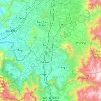
Name: Provincia de Maipo topographic map, elevation, terrain.
Location: Provincia de Maipo, Santiago Metropolitan Region, Chile (-33.98839 -70.98889 -33.52398 -70.47520)
Average elevation: 829 m
Minimum elevation: 244 m
Maximum elevation: 3,070 m
Other topographic maps
Click on a map to view its topography, its elevation and its terrain.
Santiago
Chile > Santiago Metropolitan Region > Provincia de Santiago > Santiago
The city lies in the center of the Santiago Basin, a large bowl-shaped valley consisting of broad and fertile lands surrounded by mountains. The city has a varying elevation, gradually increasing from 400 m (1,312 ft) in the western areas to more than 700 m (2,297 ft) in the eastern areas. Santiago's…
Average elevation: 724 m
Los Cántaros
Chile > Santiago Metropolitan Region > Provincia de Chacabuco > Batuco
Average elevation: 493 m
Baños Morales
Chile > Santiago Metropolitan Region > Provincia de Cordillera > San José de Maipo
Average elevation: 2,269 m
Longovilo
Chile > Santiago Metropolitan Region > Provincia de Melipilla > San Pedro
Average elevation: 181 m
Tupungato
Chile > Santiago Metropolitan Region > Provincia de Cordillera > San José de Maipo
Average elevation: 6,002 m
Río Colorado
Chile > Santiago Metropolitan Region > Provincia de Cordillera > San José de Maipo
Average elevation: 1,407 m
Valle Nevado
Chile > Santiago Metropolitan Region > Provincia de Santiago > Lo Barnechea
Due to its elevation, Valle Nevado has a subalpine climate (Dfc, according to the Köppen climate classification, bordering on Dfb and ET), with drier summers and humid winters, with an average annual precipitation of 1,042 mm (41 in). Summers are chilly and dry, while winters are cold and snowy.
Average elevation: 2,811 m
Paine Oriente
Chile > Santiago Metropolitan Region > Provincia de Maipo > Paine
Average elevation: 402 m