
Tongue River topographic map
Interactive map
Click on the map to display elevation.
About this map
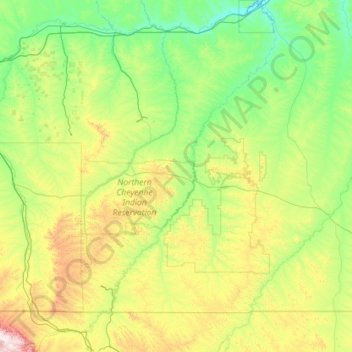
Name: Tongue River topographic map, elevation, terrain.
Average elevation: 1,050 m
Minimum elevation: 719 m
Maximum elevation: 2,598 m
The Tongue River is fed by winter snow pack from the higher elevations of the Big Horn Mountains, early snow runoff of the lower elevations in the drainage basin, and ground water from springs in the drainage basin. The river rises in March and April due to snowmelt in the lower elevations, and again in June as summer weather melts the higher elevation snow pack. The flow of water in the upper river during the summer is generally steady, but in the later months of a dry summer, irrigation will reduce the lower river to a few pools of water connected by a small trickle. The river is generally frozen during the winter months.
Other topographic maps
Click on a map to view its topography, its elevation and its terrain.
Makoshika State Park
United States of America > Montana
Makoshika State Park, Dawson County, Montana, United States of America
Average elevation: 741 m
Cooke City-Silver Gate
United States of America > Montana > Cooke City-Silver Gate
Cooke City-Silver Gate, Park County, Montana, United States of America
Average elevation: 2,686 m
Gallatin Gateway
United States of America > Montana > Gallatin Gateway
Gallatin Gateway, Gallatin County, Montana, United States of America
Average elevation: 1,519 m
Lewis & Clark Caverns State Park
United States of America > Montana
Lewis & Clark Caverns State Park, 25, Jefferson County, Montana, 59759, United States of America
Average elevation: 1,496 m
Square Butte
United States of America > Montana
Square Butte, Daniels County, Montana, United States of America
Average elevation: 830 m
Hyalite Creek
United States of America > Montana
Hyalite Creek, Gallatin County, Montana, 59714, United States of America
Average elevation: 1,355 m
Beaverhead Rock
United States of America > Montana
Beaverhead Rock, Madison County, Montana, United States of America
Average elevation: 1,492 m
Lustre
United States of America > Montana > Lustre
Lustre, Valley County, Montana, United States of America
Average elevation: 845 m
Atkins
United States of America > Montana > Atkins
Atkins, Gallatin County, Montana, United States of America
Average elevation: 1,490 m
Joplin
United States of America > Montana > Joplin
Joplin, Liberty County, Montana, United States of America
Average elevation: 1,011 m
Chicory
United States of America > Montana > Chicory
Chicory, Park County, Montana, United States of America
Average elevation: 1,511 m
Earthquake Lake
United States of America > Montana > Cliff Lake
Earthquake Lake, US 287, Cliff Lake, Madison County, Montana, United States of America
Average elevation: 2,329 m
Larslan
United States of America > Montana > Larslan
Larslan, Valley County, Montana, United States of America
Average elevation: 890 m
Fort Belknap Agency
United States of America > Montana
Fort Belknap Agency, Blaine County, Montana, 59526, United States of America
Average elevation: 746 m
Mount Frazier
United States of America > Montana
Mount Frazier, Teton County, Montana, United States of America
Average elevation: 2,042 m
Medicine Rocks State Park
United States of America > Montana
Medicine Rocks State Park, Carter County, Montana, United States of America
Average elevation: 1,021 m
Monarch
United States of America > Montana > Monarch
Monarch, Cascade County, Montana, 59463, United States of America
Average elevation: 1,548 m
Ashland
United States of America > Montana > Ashland
Ashland, Rosebud County, Montana, 59003, United States of America
Average elevation: 940 m
Threemile Buttes
United States of America > Montana
Threemile Buttes, Powder River County, Montana, United States of America
Average elevation: 1,216 m
Saypo
United States of America > Montana > Saypo
Saypo, Teton County, Montana, United States of America
Average elevation: 1,425 m
Porters Corner
United States of America > Montana > Porters Corner
Porters Corner, Granite County, Montana, United States of America
Average elevation: 1,679 m
Clark Fork
United States of America > Montana
Clark Fork, Sanders County, Montana, 59702, United States of America
Average elevation: 1,345 m