Geolocate

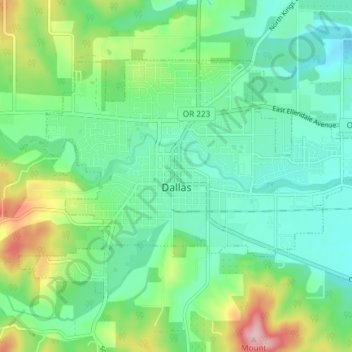
Dallas topographic map

Click on the map to display elevation.

Dallas

Dallas is along Rickreall Creek, about 15 miles (24 km) west of Salem, at an elevation of 325 feet (99 m) above sea level. It is part of the Salem Metropolitan Statistical Area.

Wikipedia (CC-BY-SA 3.0)

About this map

Name: Dallas topographic map, elevation, terrain.

Location: Dallas, Polk County, Oregon, 97338, United States (44.90285 -123.34905 44.93795 -123.27489)

Average elevation: 119 m

Minimum elevation: 67 m

Maximum elevation: 251 m

Other topographic maps

Click on a map to view its topography, its elevation and its terrain.
Buena Vista

United States > Oregon > Polk County

Average elevation: 67 m

Eola Ridge Park

United States > Oregon > Polk County > Salem

Average elevation: 103 m

Gear up for your next adventure:

Camping Shelters - Emergency and lightweight shelters for outdoor use
🧢Hiking Hats - Sun and weather protection for outdoor walks
👖Convertible Hiking Trousers - Versatile zip-off pants for changing mountain weather conditions
🗺️Ordnance Survey Maps - Essential paper maps for hiking across the UK national parks
🦶Anti-Blister Balms - Protect your feet before long topographic expeditions

As an Amazon Associate, this site earns from qualifying purchases at no extra cost to you.