
Make a donation
Gear up for your next adventure:
As an Amazon Associate, this site earns from qualifying purchases at no extra cost to you.
Monti Sibillini topographic map
Click on the map to display elevation.
Make a donation
Gear up for your next adventure:
As an Amazon Associate, this site earns from qualifying purchases at no extra cost to you.
Monti Sibillini
Con una lunghezza da nord a sud di circa 40 km, costituiti prevalentemente da rocce calcaree, formatesi sui fondali di mari caldi, presentano numerose cime che superano i 2.000m di altitudine, come la maggiore del gruppo, il monte Vettore (2.476 m s.l.m.), il pizzo della Regina (o monte Priora), il monte Bove e il monte Sibilla.
Make a donation
Gear up for your next adventure:
As an Amazon Associate, this site earns from qualifying purchases at no extra cost to you.
About this map
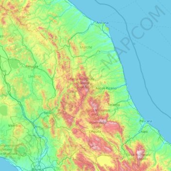
Name: Monti Sibillini topographic map, elevation, terrain.
Location: Monti Sibillini, Montemonaco, Ascoli Piceno, Marche, Italia (41.87625 12.24845 43.87625 14.24845)
Average elevation: 409 m
Minimum elevation: -2 m
Maximum elevation: 2,775 m
Make a donation
Gear up for your next adventure:
As an Amazon Associate, this site earns from qualifying purchases at no extra cost to you.