

Kexbrough topographic map
Click on the map to display elevation.
Kexbrough
Kexbrough is a village in the Barnsley district, in the county of South Yorkshire, England, on the border with West Yorkshire. The village falls within the Darton West ward of Barnsley MBC. It is located west of the M1 motorway, just south of Junction 38 at an elevation of around 351 feet (107 m) above sea level. Historically the village was known as Kexborough, and includes the hamlets of Haigh and Swithin. Until 1974 it was in the West Riding of Yorkshire.
About this map
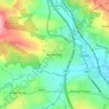
Name: Kexbrough topographic map, elevation, terrain.
Average elevation: 98 m
Minimum elevation: 52 m
Maximum elevation: 194 m
England trails, hiking, mountain biking, running and outdoor activities
Other topographic maps
Click on a map to view its topography, its elevation and its terrain.
Shafton
United Kingdom > England > Barnsley
Shafton lies to the north of Shafton Two Gates, on the road to Ryhill. It is located at approximately 53° 35' 10" North, 1° 24' West, at an elevation of around 262 feet (80 m) above sea level. Sceptun in the Domesday Book of 1086 then later in c. 1160 Scaftona meaning a farmstead marked by a pole, or made…
Average elevation: 65 m

High Hoyland
United Kingdom > England > Barnsley
High Hoyland is a village and civil parish in the Metropolitan Borough of Barnsley in South Yorkshire, England, on the border with West Yorkshire. It lies to the west of Kexbrough, and is located at approximately 53°35′10″N 1°35′30″W / 53.58611°N 1.59167°W / 53.58611; -1.59167, at an…
Average elevation: 139 m
