
Zinder topographic map
Interactive map
Click on the map to display elevation.
About this map
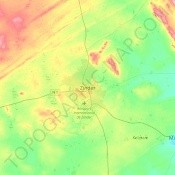
Name: Zinder topographic map, elevation, terrain.
Location: Zinder, Mirriah, Zinder Region, 07, Niger (13.64634 8.82917 13.96634 9.14917)
Average elevation: 452 m
Minimum elevation: 401 m
Maximum elevation: 544 m
Other topographic maps
Click on a map to view its topography, its elevation and its terrain.
Mirriah
Mirriah is located in the Sahel region, around 20 kilometres from the regional capital of Zinder. Mirriah's neighbouring municipalities are Gaffati to the north-west, Zermou to the north-east, Hamdara to the east, Wacha to the south-east, Gouna to the south-west and Kolléram to the west. The municipality lies…
Average elevation: 409 m