
Incahuasi topographic map
Interactive map
Click on the map to display elevation.
About this map
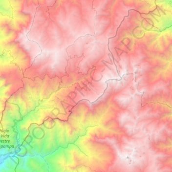
Name: Incahuasi topographic map, elevation, terrain.
Location: Incahuasi, Province of Ferreñafe, Lambayeque, Peru (-6.40198 -79.54336 -6.07403 -79.24909)
Average elevation: 2,663 m
Minimum elevation: 301 m
Maximum elevation: 4,098 m
Incahuasi (Spanish pronunciation: ; possibly from Quechua: inka Inca, wasi house) is a volcanic mountain in the Andes of South America. It lies on the border of the Argentine province of Catamarca, and the Atacama Region of Chile. Incahuasi has a summit elevation of 6,621 metres (21,722 ft) above sea level.