
Make a donation
Gear up for your next adventure:
As an Amazon Associate, this site earns from qualifying purchases at no extra cost to you.
Velburg topographic map
Click on the map to display elevation.
Make a donation
Gear up for your next adventure:
As an Amazon Associate, this site earns from qualifying purchases at no extra cost to you.
About this map
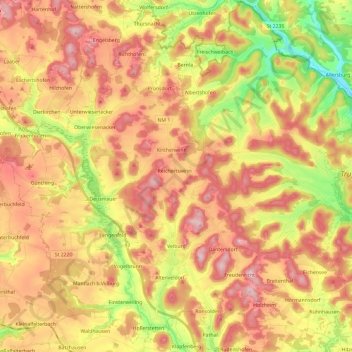
Name: Velburg topographic map, elevation, terrain.
Location: Velburg, Landkreis Neumarkt in der Oberpfalz, Bavaria, Germany (49.18648 11.55244 49.34043 11.78875)
Average elevation: 524 m
Minimum elevation: 386 m
Maximum elevation: 634 m
Make a donation
Gear up for your next adventure:
As an Amazon Associate, this site earns from qualifying purchases at no extra cost to you.
Other topographic maps
Click on a map to view its topography, its elevation and its terrain.
St. Wolfgang
Germany > Bavaria > Landkreis Neumarkt in der Oberpfalz > Dantersdorf
Average elevation: 548 m
Großbissendorf
Germany > Bavaria > Landkreis Neumarkt in der Oberpfalz > Großbissendorf
Average elevation: 492 m