Geolocate

Somerset topographic map

Click on the map to display elevation.

About this map

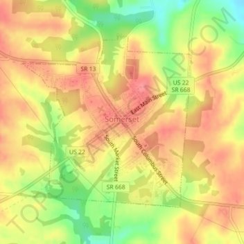
Name: Somerset topographic map, elevation, terrain.

Location: Somerset, Perry County, Ohio, 43783, United States (39.79741 -82.31366 39.81641 -82.28940)

Average elevation: 312 m

Minimum elevation: 266 m

Maximum elevation: 339 m

Other topographic maps

Click on a map to view its topography, its elevation and its terrain.

Straitsville

United States > Ohio > Perry County

Average elevation: 267 m

Mount Perry

United States > Ohio > Perry County

Average elevation: 273 m

Jonathan Creek

United States > Ohio > Perry County > Glenford

Average elevation: 289 m

Gear up for your next adventure:

📻Hand-Crank Emergency Radios - Stay updated on weather warnings in remote areas
🧼Technical Clothing Wash - Special soap to clean and restore waterproof membranes
👕Merino Base Layers - Natural temperature regulation for cold weather hiking and camping
🍳Camping Stoves - Compact stoves for outdoor cooking
📢Survival Whistles - Essential safety gear for signaling for help in mountain fog

As an Amazon Associate, this site earns from qualifying purchases at no extra cost to you.