
Jungfraujoch topographic map
Interactive map
Click on the map to display elevation.
About this map
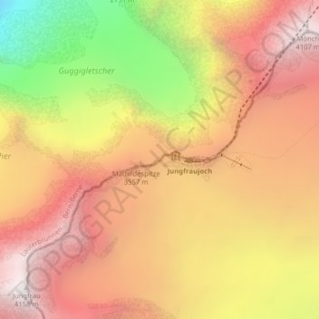
Name: Jungfraujoch topographic map, elevation, terrain.
Average elevation: 3,307 m
Minimum elevation: 2,073 m
Maximum elevation: 4,128 m
The Jungfraujoch (German: lit. "maiden saddle") is a saddle connecting two major 4000ers of the Bernese Alps: the Jungfrau and the Mönch. It lies at an elevation of 3,463 metres (11,362 ft) above sea level and is directly overlooked by the rocky prominence of the Sphinx. The Jungfraujoch is a glacier saddle, on the upper snows of the Aletsch Glacier, and part of the Jungfrau-Aletsch area, situated on the boundary between the cantons of Bern and Valais, halfway between Interlaken and Fiesch.
Other topographic maps
Click on a map to view its topography, its elevation and its terrain.
Mutthorn
Switzerland > Bern > Interlaken-Oberhasli administrative district > Lauterbrunnen
Mutthorn, Lauterbrunnen, Interlaken-Oberhasli administrative district, Oberland administrative region, Bern, Switzerland
Average elevation: 2,801 m
Birg
Switzerland > Bern > Interlaken-Oberhasli administrative district > Lauterbrunnen
Birg, Lauterbrunnen, Interlaken-Oberhasli administrative district, Oberland administrative region, Bern, 3825, Switzerland
Average elevation: 2,311 m
Jungfrau
Switzerland > Bern > Interlaken-Oberhasli administrative district > Lauterbrunnen
Jungfrau, Lauterbrunnen, Interlaken-Oberhasli administrative district, Oberland administrative region, Bern, 3801, Switzerland
Average elevation: 3,401 m