
Van topographic map
Click on the map to display elevation.
About this map
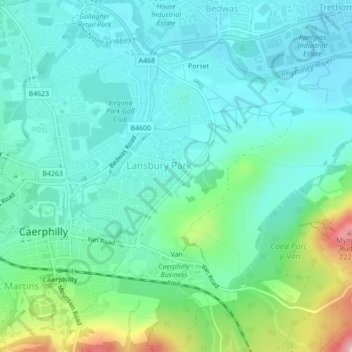
Name: Van topographic map, elevation, terrain.
Location: Van, Caerphilly County Borough, Wales, United Kingdom (51.56842 -3.21618 51.58904 -3.17648)
Average elevation: 96 m
Minimum elevation: 58 m
Maximum elevation: 224 m
Caerphilly County Borough trails, hiking, mountain biking, running and outdoor activities
Other topographic maps
Click on a map to view its topography, its elevation and its terrain.
Caerphilly Mountain
United Kingdom > Wales > Caerphilly County Borough > Caerphilly
Average elevation: 171 m
Rudry Common
United Kingdom > Wales > Caerphilly County Borough > Trethomas > Rudry
Average elevation: 131 m
Bedwellty
United Kingdom > Wales > Caerphilly County Borough > Bargoed > Aberbargoed
Average elevation: 253 m