
Nötsch im Gailtal topographic map
Interactive map
Click on the map to display elevation.
About this map
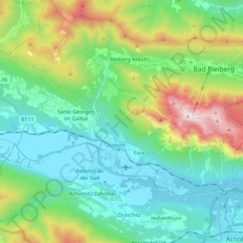
Name: Nötsch im Gailtal topographic map, elevation, terrain.
Location: Nötsch im Gailtal, Bezirk Villach-Land, Carinthia, Austria (46.56786 13.54335 46.63406 13.70118)
Average elevation: 966 m
Minimum elevation: 538 m
Maximum elevation: 2,158 m
Other topographic maps
Click on a map to view its topography, its elevation and its terrain.
Semering
Austria > Carinthia > Bezirk Villach-Land > Nötsch im Gailtal > Kühweg
Semering, Kühweg, Nötsch im Gailtal, Bezirk Villach-Land, Carinthia, 9612, Austria
Average elevation: 826 m