
Bujumbura topographic map
Interactive map
Click on the map to display elevation.
About this map
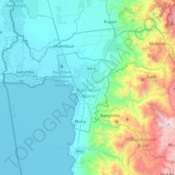
Name: Bujumbura topographic map, elevation, terrain.
Location: Bujumbura, Bujumbura Mairie, Burundi (-3.52381 29.20750 -3.20381 29.52750)
Average elevation: 1,106 m
Minimum elevation: 763 m
Maximum elevation: 2,520 m
Bujumbura features a tropical savanna climate (Köppen: Aw) bordering on a hot semi-arid climate (BSh). There are distinct wet and dry seasons. Its wet season is from October to April, while the dry season covers the remaining five months. Despite being located close to the equator, Bujumbura is not as hot as one might expect, due to its altitude. Average temperatures are constant throughout the course of the year with the high temperature at around 29 °C (84 °F) and the low temperature at around 19 °C (66 °F).