
Tehuacán topographic map
Interactive map
Click on the map to display elevation.
About this map
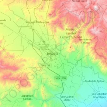
Name: Tehuacán topographic map, elevation, terrain.
Location: Tehuacán, Puebla, 75700, México (18.29999 -97.55036 18.61999 -97.23036)
Average elevation: 1,824 m
Minimum elevation: 1,077 m
Maximum elevation: 3,057 m
Tiene una altitud de 1620 metros sobre el nivel del mar. El municipio de Tehuacán colinda al norte con los municipios de Tapanco de López, Santiago Miahuatlán, Nicolás Bravo y Vicente Guerrero, San Antonio Cañada, Ajalpan y San Gabriel Chilac y Zapotitlán, al oeste con Atexcal, Juan N. Méndez, Tlacotepec de Benito Juárez y Tapanco de López.
Other topographic maps
Click on a map to view its topography, its elevation and its terrain.
Valsequillo
México > Puebla > Tehuacán > Tehuacán
Valsequillo, Tehuacán, Puebla, 75700, México
Average elevation: 1,656 m
Cristo Rey
México > Puebla > Tehuacán > Tehuacán
Cristo Rey, Tehuacán, Puebla, 75809, México
Average elevation: 1,722 m
San Pablo Tepetzingo
San Pablo Tepetzingo, Tehuacán, Puebla, 75790, México
Average elevation: 1,415 m