
Make a donation
Gear up for your next adventure:
As an Amazon Associate, this site earns from qualifying purchases at no extra cost to you.
Gorakhpur topographic map
Click on the map to display elevation.
Make a donation
Gear up for your next adventure:
As an Amazon Associate, this site earns from qualifying purchases at no extra cost to you.
Gorakhpur
Gorakhpur city is located in the north-easterrn part of Uttar Pradesh, India, within the Indo-Gangetic Plain. The city's geographical coordinates are 26.7663° N latitude and 83.3689° E longitude, with an altitude of 69 metres (229 feet) above sea level. Gorakhpur is situated about 100 km from the Nepal border, 193 km from Varanasi, 260 km from Patna and 270 km from Lucknow. Gorakhpur has been ranked 4th best “National Clean Air City” under (Category 2 3-10L Population cities) in India.
Make a donation
Gear up for your next adventure:
As an Amazon Associate, this site earns from qualifying purchases at no extra cost to you.
About this map
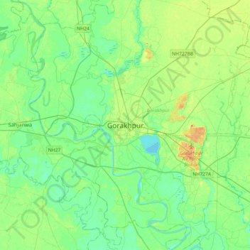
Name: Gorakhpur topographic map, elevation, terrain.
Location: Gorakhpur, Uttar Pradesh, 273001, India (26.60002 83.20681 26.92002 83.52681)
Average elevation: 79 m
Minimum elevation: 67 m
Maximum elevation: 104 m
Make a donation
Gear up for your next adventure:
As an Amazon Associate, this site earns from qualifying purchases at no extra cost to you.