Geolocate

Lodsworth topographic map

Click on the map to display elevation.

About this map

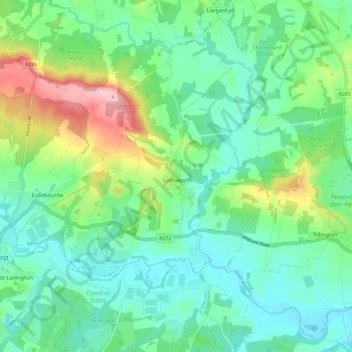
Name: Lodsworth topographic map, elevation, terrain.

Location: Lodsworth, Chichester, West Sussex, England, United Kingdom (50.96435 -0.70442 51.03784 -0.65351)

Average elevation: 58 m

Minimum elevation: 7 m

Maximum elevation: 194 m

West Sussex trails, hiking, mountain biking, running and outdoor activities

Other topographic maps

Click on a map to view its topography, its elevation and its terrain.

Gear up for your next adventure:

📱Rugged Phone Cases - Heavy-duty protection for smartphones used as secondary GPS tools
📷Camera Straps - Secure straps for carrying cameras while walking
🐕Dog Hiking Gear - Equipment for hiking safely with dogs
🧘Folding Sit Mats - Dry and warm seat for map-reading breaks on damp ground
Altimeter Watches - Watches measuring altitude for mountain activities

As an Amazon Associate, this site earns from qualifying purchases at no extra cost to you.