
Ruine Homburg topographic map
Interactive map
Click on the map to display elevation.
About this map
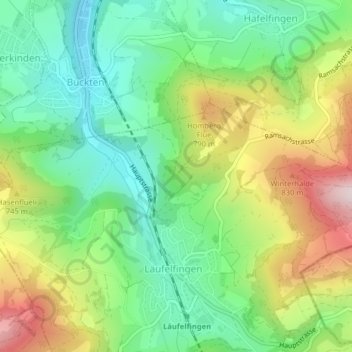
Name: Ruine Homburg topographic map, elevation, terrain.
Average elevation: 642 m
Minimum elevation: 474 m
Maximum elevation: 922 m
Die Ruine der Höhenburg befindet sich auf 650 m ü. M. über der engsten Stelle des nach ihr benannten Homburgertals. Von den SBB-Stationen Buckten und Läufelfingen sowie von Bad Ramsach aus erreicht man sie zu Fuss in ca. 30 Minuten. Die Wege sind gelb ausgeschildert. Von der Aussichtsplattform des Wohnturms hat man einen Blick auf die umgebenden Jurahöhen.