Geolocate

Distington topographic map

Click on the map to display elevation.

About this map

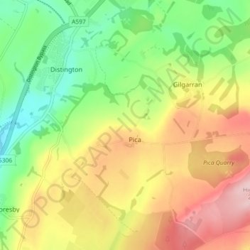
Name: Distington topographic map, elevation, terrain.

Location: Distington, Pica, Cumberland, England, United Kingdom (54.56589 -3.55713 54.60734 -3.48533)

Average elevation: 130 m

Minimum elevation: 36 m

Maximum elevation: 242 m

Cumberland trails, hiking, mountain biking, running and outdoor activities

Gear up for your next adventure:

Lightweight Tents - Compact tents for backpacking and trekking
🧥Packable Down Jackets - Lightweight warmth that compresses small in your bag
🥾Trekking Poles - Poles to improve stability on uneven terrain
🔭Compact Hiking Binoculars - Lightweight optics for scouting terrain and spotting wildlife
🐕Dog Hiking Gear - Equipment for hiking safely with dogs

As an Amazon Associate, this site earns from qualifying purchases at no extra cost to you.