
Lake Township topographic map
Interactive map
Click on the map to display elevation.
About this map
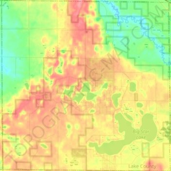
Name: Lake Township topographic map, elevation, terrain.
Location: Lake Township, Lake County, Michigan, 49394, United States (43.81463 -86.03865 43.90237 -85.91833)
Average elevation: 253 m
Minimum elevation: 216 m
Maximum elevation: 288 m
Other topographic maps
Click on a map to view its topography, its elevation and its terrain.
Irons
United States > Michigan > Lake County
Irons, Eden Township, Lake County, Michigan, 49644, United States
Average elevation: 263 m
Peacock
United States > Michigan > Lake County
Peacock, Peacock Township, Lake County, Michigan, United States
Average elevation: 275 m
Sauble
United States > Michigan > Lake County
Sauble, Sauble Township, Lake County, Michigan, United States
Average elevation: 227 m
Sunshine Lake
United States > Michigan > Lake County
Sunshine Lake, Elk Township, Lake County, Michigan, United States
Average elevation: 238 m
Yates Township
United States > Michigan > Lake County
Yates Township, Lake County, Michigan, 49642, United States
Average elevation: 286 m