
Town of Colonie topographic map
Interactive map
Click on the map to display elevation.
About this map
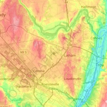
Name: Town of Colonie topographic map, elevation, terrain.
Location: Town of Colonie, Albany County, New York, United States (42.67288 -73.93355 42.82258 -73.68436)
Average elevation: 79 m
Minimum elevation: -1 m
Maximum elevation: 166 m
Other topographic maps
Click on a map to view its topography, its elevation and its terrain.
Latham
United States > New York > Albany County > Town of Colonie > Latham
Latham, Town of Colonie, Albany County, New York, 12110, United States
Average elevation: 96 m