
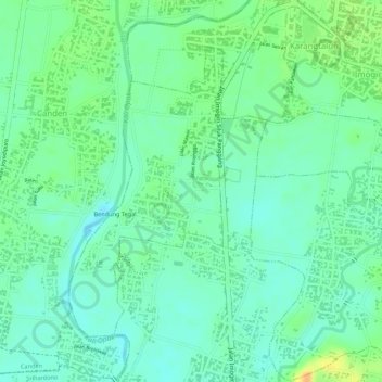
Kebonagung topographic map
Interactive map
Click on the map to display elevation.
About this map
Name: Kebonagung topographic map, elevation, terrain.
Average elevation: 30 m
Minimum elevation: 16 m
Maximum elevation: 52 m
Other topographic maps
Click on a map to view its topography, its elevation and its terrain.
Pantai Drini
Indonesia > Special Region of Yogyakarta > Gunung Kidul Regency > Banjarejo
Average elevation: 20 m
Sungai Code
Indonesia > Special Region of Yogyakarta > Sleman Regency > Yogyakarta
Average elevation: 110 m
Pakem
Indonesia > Special Region of Yogyakarta > Sleman Regency > Pakembinangun
Average elevation: 409 m
Minggir
Indonesia > Special Region of Yogyakarta > Sleman Regency > Sendangagung
Average elevation: 142 m
Kalasan
Indonesia > Special Region of Yogyakarta > Sleman Regency > Tirtomartani
Average elevation: 143 m
Cangkringan
Indonesia > Special Region of Yogyakarta > Sleman Regency > Argomulyo
Average elevation: 453 m
Gedangan
Indonesia > Special Region of Yogyakarta > Gunung Kidul Regency > Gedangsari > Hargomulyo
Average elevation: 325 m
Margoagung
Indonesia > Special Region of Yogyakarta > Sleman Regency > Margoagung
Average elevation: 194 m
Ngipiksari
Indonesia > Special Region of Yogyakarta > Sleman Regency > Hargobinangun > Kaliurang
Average elevation: 794 m
taman sari
Indonesia > Special Region of Yogyakarta > Sleman Regency > Sinduharjo
Average elevation: 173 m
Pantai Ngandong
Indonesia > Special Region of Yogyakarta > Gunung Kidul Regency > Sidoharjo
Average elevation: 23 m
SUNGAI OPAK
Indonesia > Special Region of Yogyakarta > Sleman Regency > Leses
Average elevation: 236 m
Karang Sari
Indonesia > Special Region of Yogyakarta > Gunung Kidul Regency > Karangsari
Average elevation: 348 m
Pantai Krakal Barat
Indonesia > Special Region of Yogyakarta > Gunung Kidul Regency > Kanigoro
Average elevation: 27 m
Pakem Binangun
Indonesia > Special Region of Yogyakarta > Sleman Regency > Pakembinangun
Average elevation: 448 m
Lumbung Rejo
Indonesia > Special Region of Yogyakarta > Sleman Regency > Lumbungrejo
Average elevation: 338 m
Tempel
Indonesia > Special Region of Yogyakarta > Sleman Regency > Lumbungrejo
Average elevation: 323 m
Margo Rejo
Indonesia > Special Region of Yogyakarta > Sleman Regency > Margorejo
Average elevation: 304 m
Kelurahan Ngargosari
Indonesia > Special Region of Yogyakarta > Kulon Progo > Ngargosari
Average elevation: 615 m
Sumber Rejo
Indonesia > Special Region of Yogyakarta > Sleman Regency > Sumberrejo
Average elevation: 233 m
Kemiri Kebo
Indonesia > Special Region of Yogyakarta > Sleman Regency > Girikerto
Average elevation: 713 m
Waduk Sermo
Indonesia > Special Region of Yogyakarta > Kulon Progo > Hargowilis
Average elevation: 171 m
Ngasemayu
Indonesia > Special Region of Yogyakarta > Gunung Kidul Regency > Patuk
Average elevation: 222 m
Tlogo Putri Kaliurang
Indonesia > Special Region of Yogyakarta > Sleman Regency > Hargobinangun > Kaliurang
Average elevation: 948 m
Gunung Malang
Indonesia > Special Region of Yogyakarta > Bantul Regency > Segoroyoso
Average elevation: 75 m
Pantai Porok
Indonesia > Special Region of Yogyakarta > Gunung Kidul Regency > Kemadang
Average elevation: 20 m
Sepanjang Beach
Indonesia > Special Region of Yogyakarta > Gunung Kidul Regency > Kemadang
Average elevation: 15 m
Wisdom park
Indonesia > Special Region of Yogyakarta > Sleman Regency > Catur tunggal
Average elevation: 136 m
Jogotirto
Indonesia > Special Region of Yogyakarta > Sleman Regency > Jogotirto
Average elevation: 96 m
Kaliurang
Indonesia > Special Region of Yogyakarta > Sleman Regency > Hargobinangun
Average elevation: 858 m
Gapuro Gedongkuning
Indonesia > Special Region of Yogyakarta > Bantul Regency > Banguntapan
Average elevation: 103 m
Pantai Jungwok
Indonesia > Special Region of Yogyakarta > Gunung Kidul Regency > Jepitu
Average elevation: 15 m
Bangun Kerto
Indonesia > Special Region of Yogyakarta > Sleman Regency > Bangunkerto
Average elevation: 379 m
Ngoro Oro
Indonesia > Special Region of Yogyakarta > Gunung Kidul Regency > Ngoro-oro > Ngoro Oro
Average elevation: 291 m
Embung Tambakboyo
Indonesia > Special Region of Yogyakarta > Sleman Regency > Condongcatur > Condong Catur
Average elevation: 164 m