
Olt topographic map
Interactive map
Click on the map to display elevation.
About this map
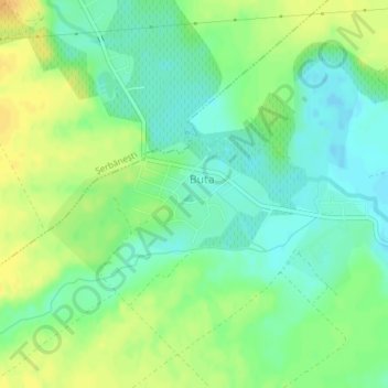
Name: Olt topographic map, elevation, terrain.
Location: Buta, Olt, 237101, Romania (44.30322 24.70175 44.31098 24.71704)
Average elevation: 133 m
Minimum elevation: 120 m
Maximum elevation: 147 m
Other topographic maps
Click on a map to view its topography, its elevation and its terrain.
Cornii de Sus
Cornii de Sus, Tătărăști, Bacău, 607622, Romania
Average elevation: 184 m
Tihuța Pass
Romania > Bistrița-Năsăud > Tiha Bârgăului
Tihuța Pass, Tiha Bârgăului, Bistrița-Năsăud, 427363, Romania
Average elevation: 1,104 m
Parcul Octav Băncilă
Parcul Octav Băncilă, Canta, Gară, Iași, Iași Metropolitan Area, Iași, Romania
Average elevation: 72 m
Mărtinești
Mărtinești, Tureni, Cluj Metropolitan Area, Cluj, 407563, Romania
Average elevation: 585 m
Peana
Romania > Cluj > Cluj-Napoca
Peana, Cluj-Napoca, Cluj Metropolitan Area, Cluj, 407271, Romania
Average elevation: 741 m
Dorolea
Dorolea, Livezile, Bistrița-Năsăud, 427122, Romania
Average elevation: 488 m
Carpathian Mountains
Carpathian Mountains, Toplița, Harghita, 535705, Romania
Average elevation: 980 m