
Make a donation
Gear up for your next adventure:
As an Amazon Associate, this site earns from qualifying purchases at no extra cost to you.
Chief topographic map
Click on the map to display elevation.
Make a donation
Gear up for your next adventure:
As an Amazon Associate, this site earns from qualifying purchases at no extra cost to you.
About this map
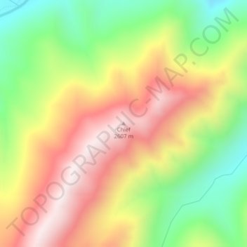
Name: Chief topographic map, elevation, terrain.
Location: Chief, Valley County, Idaho, United States (44.82474 -115.28214 44.82484 -115.28204)
Average elevation: 2,249 m
Minimum elevation: 1,872 m
Maximum elevation: 2,625 m
Make a donation
Gear up for your next adventure:
As an Amazon Associate, this site earns from qualifying purchases at no extra cost to you.
Other topographic maps
Click on a map to view its topography, its elevation and its terrain.
McCall
United States > Idaho > Valley County
McCall is located at 44°54′39″N 116°6′11″W / 44.91083°N 116.10306°W / 44.91083; -116.10306 (44.910906, -116.103087), at an elevation of 5,013 feet (1,528 m) above sea level.
Average elevation: 1,546 m
Donnelly
United States > Idaho > Valley County
Donnelly is located at 44°43′49″N 116°4′37″W / 44.73028°N 116.07694°W / 44.73028; -116.07694, at an elevation of 4,865 feet (1,483 m) above sea level. According to the United States Census Bureau, the city has a total area of 0.45 square miles (1.17 km2), all of it land.
Average elevation: 1,483 m
McCall
United States > Idaho > Valley County
McCall is located at 44°54′39″N 116°6′11″W / 44.91083°N 116.10306°W / 44.91083; -116.10306 (44.910906, -116.103087),[7] at an elevation of 5,013 feet (1,528 m) above sea level.
Average elevation: 1,546 m
Make a donation
Gear up for your next adventure:
As an Amazon Associate, this site earns from qualifying purchases at no extra cost to you.
Make a donation
Gear up for your next adventure:
As an Amazon Associate, this site earns from qualifying purchases at no extra cost to you.
McCall
United States > Idaho > Valley County
Brundage Mountain, northwest of McCall, opened in November 1961. Brundage has a summit elevation of 7,803 feet (2,380 m) above sea level, and a vertical drop of 1,921 feet (590 m). The slopes on Brundage Mountain are primarily west-facing and the mountain's average snowfall exceeds 320 inches (810 cm). It…
Average elevation: 1,546 m