
Caledon topographic map
Interactive map
Click on the map to display elevation.
About this map
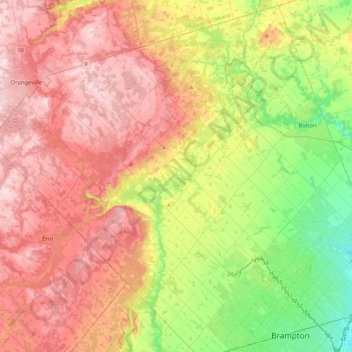
Name: Caledon topographic map, elevation, terrain.
Location: Caledon, Peel Region, Golden Horseshoe, Ontario, Canada (43.67487 -80.14426 43.98975 -79.69486)
Average elevation: 331 m
Minimum elevation: 173 m
Maximum elevation: 490 m
Other topographic maps
Click on a map to view its topography, its elevation and its terrain.
Caledon East
Canada > Ontario > Peel Region > Caledon
Caledon East, Caledon, Peel Region, Golden Horseshoe, Ontario, L7C 1H9, Canada
Average elevation: 308 m