
Dougnac topographic map
Interactive map
Click on the map to display elevation.
About this map
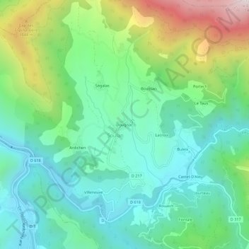
Name: Dougnac topographic map, elevation, terrain.
Average elevation: 730 m
Minimum elevation: 460 m
Maximum elevation: 1,390 m
Other topographic maps
Click on a map to view its topography, its elevation and its terrain.
Cap d'Escouades
France > Occitanie > Ariège > Soulan
Cap d'Escouades, Soulan, Saint-Girons, Ariège, Occitanie, France métropolitaine, 09320, France
Average elevation: 932 m