
Pian Bosco topographic map
Interactive map
Click on the map to display elevation.
About this map
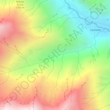
Name: Pian Bosco topographic map, elevation, terrain.
Location: Pian Bosco, Ronco Canavese, Turin, Piémont, Italie (45.48228 7.48532 45.50228 7.50532)
Average elevation: 1,702 m
Minimum elevation: 994 m
Maximum elevation: 2,500 m
Other topographic maps
Click on a map to view its topography, its elevation and its terrain.
Alpe Del Cresto
Italie > Piémont > Turin > Ronco Canavese > Masonaie
Alpe Del Cresto, Masonaie, Ronco Canavese, Turin, Piémont, Italie
Average elevation: 1,442 m
Scandosio
Italie > Piémont > Turin > Ronco Canavese
Scandosio, Ronco Canavese, Turin, Piémont, Italie
Average elevation: 1,441 m