
Porcupine topographic map
Interactive map
Click on the map to display elevation.
About this map
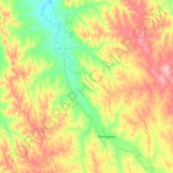
Name: Porcupine topographic map, elevation, terrain.
Average elevation: 1,013 m
Minimum elevation: 905 m
Maximum elevation: 1,125 m
Other topographic maps
Click on a map to view its topography, its elevation and its terrain.
Badlands National Park
United States > South Dakota > Oglala Lakota County
Badlands National Park, Oglala Lakota County, South Dakota, 57750, United States
Average elevation: 848 m