
Allendale topographic map
Interactive map
Click on the map to display elevation.
About this map
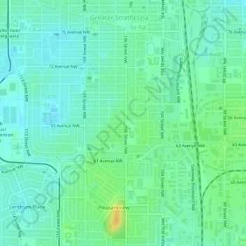
Name: Allendale topographic map, elevation, terrain.
Location: Allendale, Greater Strathcona, Edmonton, Alberta, Canada (53.49796 -113.51207 53.50658 -113.49768)
Average elevation: 673 m
Minimum elevation: 665 m
Maximum elevation: 691 m
Other topographic maps
Click on a map to view its topography, its elevation and its terrain.
Lake District
Lake District, Edmonton, Alberta, Canada
Average elevation: 684 m
Lakewood
Canada > Alberta > Edmonton > Mill Woods
Lakewood, Mill Woods, Edmonton, Alberta, Canada
Average elevation: 689 m
The Meadows District
Larkspur, West Meadows, The Meadows District, Edmonton, Alberta, Canada
Average elevation: 707 m
Central Core
Downtown, Central Core, Edmonton, Alberta, Canada
Average elevation: 653 m
The Meadows
Tamarack, The Meadows, Edmonton, Alberta, Canada
Average elevation: 718 m