
Make a donation
Gear up for your next adventure:
As an Amazon Associate, this site earns from qualifying purchases at no extra cost to you.
Puy Pariou topographic map
Click on the map to display elevation.
Make a donation
Gear up for your next adventure:
As an Amazon Associate, this site earns from qualifying purchases at no extra cost to you.
Puy Pariou
Culminant à 1 209 mètres d'altitude, il s'élève 250 m au-dessus du socle cristallin qui constitue la plaine environnante. Il a une forme typique de volcan de type strombolien et son cratère est formé de deux cratères emboîtés. Le cratère central, le plus élevé et le plus récent, forme un cercle presque parfait. Il atteint 90 mètres de profondeur et 200 m de diamètre. Les deux cratères ne sont pas dans le même axe, contrairement à ceux du puy de Côme. On compare souvent le puy Pariou au Vésuve, avec son cône récent surmontant une somma.
Make a donation
Gear up for your next adventure:
As an Amazon Associate, this site earns from qualifying purchases at no extra cost to you.
About this map
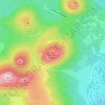
Name: Puy Pariou topographic map, elevation, terrain.
Average elevation: 1,039 m
Minimum elevation: 916 m
Maximum elevation: 1,220 m
Make a donation
Gear up for your next adventure:
As an Amazon Associate, this site earns from qualifying purchases at no extra cost to you.