
Cherryville topographic map
Interactive map
Click on the map to display elevation.
About this map
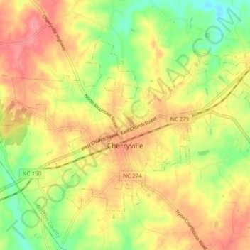
Name: Cherryville topographic map, elevation, terrain.
Average elevation: 277 m
Minimum elevation: 232 m
Maximum elevation: 314 m
Cherryville is located in Cherryville Township at 35°22′52″N 81°22′45″W / 35.38111°N 81.37917°W / 35.38111; -81.37917 (35.381169, -81.379168) at an elevation of 1,007 feet (307 m). According to the United States Census Bureau, the city covers a total area of 5.50 square miles (14.25 km2), of which 5.49 square miles (14.22 km2) is land and 0.012 square miles (0.03 km2), or 0.21%, is water. The small Cherryville City Reservoir is located just southeast of the city limits.
Other topographic maps
Click on a map to view its topography, its elevation and its terrain.
Mount Holly
United States > North Carolina > Gaston County > Mount Holly
Mount Holly, Gaston County, North Carolina, 28120, United States
Average elevation: 208 m
Gastonia
United States > North Carolina > Gaston County
Gastonia, Gaston County, North Carolina, United States
Average elevation: 230 m
Lowell
United States > North Carolina > Gaston County > Lowell
Lowell, Gaston County, North Carolina, 28098, United States
Average elevation: 219 m