
North Lima topographic map
Interactive map
Click on the map to display elevation.
About this map
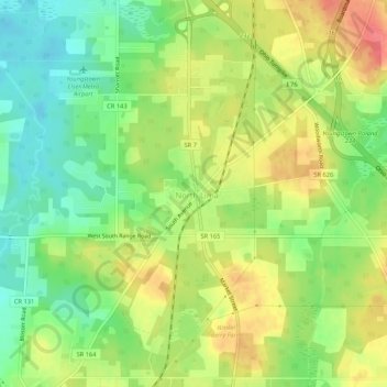
Name: North Lima topographic map, elevation, terrain.
Location: North Lima, Mahoning County, Ohio, 44452, United States (40.92839 -80.67896 40.96839 -80.63896)
Average elevation: 335 m
Minimum elevation: 303 m
Maximum elevation: 372 m
Other topographic maps
Click on a map to view its topography, its elevation and its terrain.
Youngstown
United States > Ohio > Mahoning County
Youngstown, Mahoning County, Ohio, United States
Average elevation: 307 m
North Jackson
United States > Ohio > Mahoning County
North Jackson, Mahoning County, Ohio, 44451, United States
Average elevation: 311 m
Austintown
United States > Ohio > Mahoning County
Austintown, Mahoning County, Ohio, 44515, United States
Average elevation: 318 m
Juliana Kurinka Play Area
United States > Ohio > Mahoning County > Youngstown
Juliana Kurinka Play Area, Old Furnace District, West Side, Youngstown, Mahoning County, Ohio, United States
Average elevation: 303 m
Lake Milton
United States > Ohio > Mahoning County
Lake Milton, Milton Township, Mahoning County, Ohio, 44429, United States
Average elevation: 299 m