Geolocate

Pontypridd topographic map

Click on the map to display elevation.

About this map

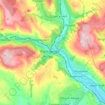
Name: Pontypridd topographic map, elevation, terrain.

Location: Pontypridd, Rhondda Cynon Taf, Wales, CF, United Kingdom (51.56010 -3.38494 51.64010 -3.30494)

Average elevation: 184 m

Minimum elevation: 37 m

Maximum elevation: 380 m

Wales trails, hiking, mountain biking, running and outdoor activities

Gear up for your next adventure:

🧴Sport Sunscreen Sticks - High-protection sunblock that won't run into your eyes on the trail
🧢Waterproof Hiking Hats - Keep the rain off your face while studying topographic maps
🔦Head Torches - Hands-free lighting for hiking and camping
🎒Hiking Daypacks (20L) - Compact backpacks for day trips and technical mountain ascents
📱Phone Mounts for Hiking - Secure mounts to carry your phone on trails

As an Amazon Associate, this site earns from qualifying purchases at no extra cost to you.