
Thank you for supporting this site ❤️
Make a donation
Make a donation
Gear up for your next adventure:
As an Amazon Associate, this site earns from qualifying purchases at no extra cost to you.
Ocrabamba topographic map
Click on the map to display elevation.
Thank you for supporting this site ❤️
Make a donation
Make a donation
Gear up for your next adventure:
As an Amazon Associate, this site earns from qualifying purchases at no extra cost to you.
About this map
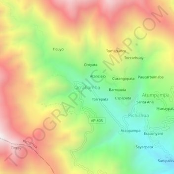
Name: Ocrabamba topographic map, elevation, terrain.
Location: Ocrabamba, Pichirhua, Provincia de Abancay, Apurímac, Perú (-13.87473 -73.10557 -13.83473 -73.06557)
Average elevation: 3,181 m
Minimum elevation: 2,519 m
Maximum elevation: 3,891 m
Thank you for supporting this site ❤️
Make a donation
Make a donation
Gear up for your next adventure:
As an Amazon Associate, this site earns from qualifying purchases at no extra cost to you.