
El Biod topographic map
Interactive map
Click on the map to display elevation.
About this map
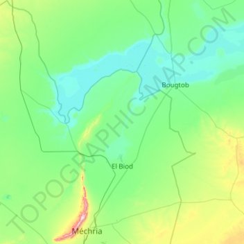
Name: El Biod topographic map, elevation, terrain.
Location: El Biod, Mecheria District, Naâma, Algeria (33.49835 -0.77199 34.32588 0.16964)
Average elevation: 1,077 m
Minimum elevation: 977 m
Maximum elevation: 1,709 m
Other topographic maps
Click on a map to view its topography, its elevation and its terrain.
Mecheria
Algeria > Naâma > Mecheria District > Mecheria
Mecheria, Mecheria District, Naâma, Algeria
Average elevation: 1,141 m