Geolocate

Bursa topographic map

Click on the map to display elevation.

About this map

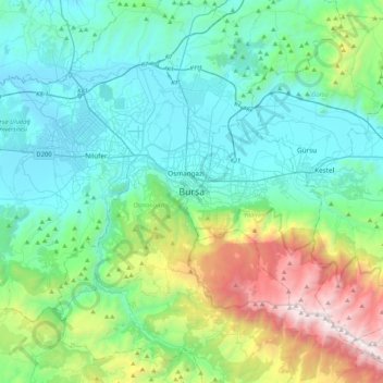
Name: Bursa topographic map, elevation, terrain.

Location: Bursa, Osmangazi, Bursa, Marmara Region, 16010, Turkey (40.02257 28.90750 40.34257 29.22750)

Average elevation: 598 m

Minimum elevation: 59 m

Maximum elevation: 2,534 m

Other topographic maps

Click on a map to view its topography, its elevation and its terrain.

Adalet Mahallesi

Turkey > Osmangazi

Average elevation: 104 m

Elmaçukur Mahallesi

Turkey > Osmangazi

Average elevation: 965 m

Gear up for your next adventure:

🚲Cycling GPS Computers - Track elevation and topographic routes on two wheels
🧰Survival Kits - Emergency tools for remote environments
🧊Personal Water Filters - Drink safely from mountain streams marked on your map
🗺️Ordnance Survey Maps - Official UK maps for walking and outdoor activities
🧘Folding Sit Mats - Dry and warm seat for map-reading breaks on damp ground

As an Amazon Associate, this site earns from qualifying purchases at no extra cost to you.