
Borgworm topographic map
Interactive map
Click on the map to display elevation.
About this map
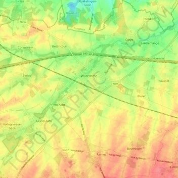
Name: Borgworm topographic map, elevation, terrain.
Location: Borgworm, Luik, Wallonië, 4300, België (50.65549 5.21376 50.72904 5.31328)
Average elevation: 125 m
Minimum elevation: 87 m
Maximum elevation: 156 m
Other topographic maps
Click on a map to view its topography, its elevation and its terrain.
Ville-en-Hesbaye
België > Luik > Borgworm > Ville-en-Hesbaye
Ville-en-Hesbaye, Braives, Borgworm, Luik, Wallonië, 4260, België
Average elevation: 146 m