
Make a donation
Gear up for your next adventure:
As an Amazon Associate, this site earns from qualifying purchases at no extra cost to you.
Aden City topographic map
Click on the map to display elevation.
Make a donation
Gear up for your next adventure:
As an Amazon Associate, this site earns from qualifying purchases at no extra cost to you.
Aden City
Aden is located on the coast of the Gulf of Aden, and is about 363 kilometers away from the capital, Sana’a. It is located between latitudes 47 and 12 north of the equator, and at an altitude of 6 meters above sea level. It is surrounded by Lahj Governorate to the north and east, and the Governorate of Abyan is from the northwest, and Aden has an air port represented by Aden International Airport, and a sea port represented by the port of Aden, and it has land routes from the north linking it to Hajj, Abyan and Taiz.
Make a donation
Gear up for your next adventure:
As an Amazon Associate, this site earns from qualifying purchases at no extra cost to you.
About this map
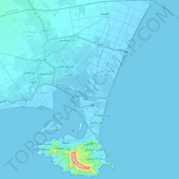
Name: Aden City topographic map, elevation, terrain.
Location: Aden City, Aden Governorate, Yemen (12.75089 44.90904 12.94122 45.09813)
Average elevation: 11 m
Minimum elevation: -9 m
Maximum elevation: 512 m
Make a donation
Gear up for your next adventure:
As an Amazon Associate, this site earns from qualifying purchases at no extra cost to you.
Other topographic maps
Click on a map to view its topography, its elevation and its terrain.
Make a donation
Gear up for your next adventure:
As an Amazon Associate, this site earns from qualifying purchases at no extra cost to you.