Geolocate

Edjere topographic map

Click on the map to display elevation.

About this map

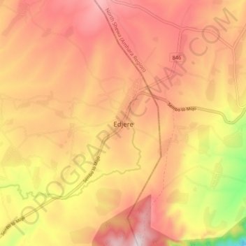
Name: Edjere topographic map, elevation, terrain.

Location: Edjere, East Shewa, Oromia Region, Ethiopia (8.73878 39.22148 8.81878 39.30148)

Average elevation: 2,228 m

Minimum elevation: 1,900 m

Maximum elevation: 2,425 m

Gear up for your next adventure:

🧼Biodegradable Soap - Leave-no-trace hygiene for multi-day mountain treks
🐕Dog Hiking Gear - Equipment for hiking safely with dogs
🥼Base Layers - Thermal base layers for temperature regulation
Altimeter Watches - Watches measuring altitude for mountain activities
🗺️Ordnance Survey Maps - Official UK maps for walking and outdoor activities

As an Amazon Associate, this site earns from qualifying purchases at no extra cost to you.