
Make a donation
Gear up for your next adventure:
As an Amazon Associate, this site earns from qualifying purchases at no extra cost to you.
Ama Dablam topographic map
Click on the map to display elevation.
Make a donation
Gear up for your next adventure:
As an Amazon Associate, this site earns from qualifying purchases at no extra cost to you.
Ama Dablam
Ama Dablam was first climbed on 13 March 1961 by Mike Gill (NZ), Barry Bishop (US), Mike Ward (UK) and Wally Romanes (NZ) via the Southwest Ridge. They were well-acclimatised to altitude, having wintered over at 5,800 metres (19,029 ft) near the base of the peak as part of the 1960–61 Silver Hut expedition, led by Sir Edmund Hillary.
Make a donation
Gear up for your next adventure:
As an Amazon Associate, this site earns from qualifying purchases at no extra cost to you.
About this map
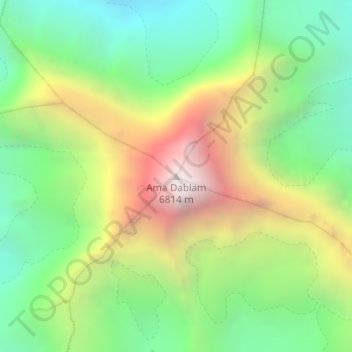
Name: Ama Dablam topographic map, elevation, terrain.
Average elevation: 5,625 m
Minimum elevation: 4,878 m
Maximum elevation: 6,777 m
Make a donation
Gear up for your next adventure:
As an Amazon Associate, this site earns from qualifying purchases at no extra cost to you.
Other topographic maps
Click on a map to view its topography, its elevation and its terrain.
Make a donation
Gear up for your next adventure:
As an Amazon Associate, this site earns from qualifying purchases at no extra cost to you.