
Les Mazoirs topographic map
Interactive map
Click on the map to display elevation.
About this map
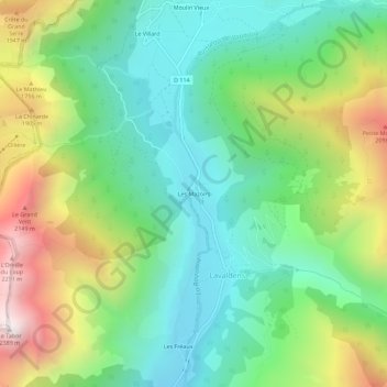
Name: Les Mazoirs topographic map, elevation, terrain.
Average elevation: 1,476 m
Minimum elevation: 1,013 m
Maximum elevation: 2,374 m
Other topographic maps
Click on a map to view its topography, its elevation and its terrain.
Moulin Vieux
France > Auvergne-Rhône-Alpes > Isère > Lavaldens
Moulin Vieux, Lavaldens, Grenoble, Isère, Auvergne-Rhône-Alpes, Metropolitan France, 38350, France
Average elevation: 1,534 m