
Bad Oldesloe topographic map
Interactive map
Click on the map to display elevation.
About this map
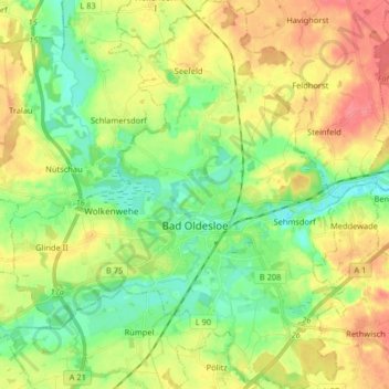
Name: Bad Oldesloe topographic map, elevation, terrain.
Location: Bad Oldesloe, Stormarn, Sleeswijk-Holstein, 23843, Duitsland (53.76924 10.29597 53.86522 10.43654)
Average elevation: 30 m
Minimum elevation: 1 m
Maximum elevation: 67 m
Other topographic maps
Click on a map to view its topography, its elevation and its terrain.
Noord-Duitse Laagvlakte
Duitsland > Sleeswijk-Holstein > Stormarn > Trittau
Noord-Duitse Laagvlakte, Trittau, Stormarn, Sleeswijk-Holstein, 22946, Duitsland
Average elevation: 36 m
Trenthorst
Duitsland > Sleeswijk-Holstein > Stormarn > Westerau
Trenthorst, Westerau, Nordstormarn, Stormarn, Sleeswijk-Holstein, 23860, Duitsland
Average elevation: 25 m
Trenthorst
Duitsland > Sleeswijk-Holstein > Stormarn > Westerau > Trenthorst
Trenthorst, Westerau, Nordstormarn, Stormarn, Sleeswijk-Holstein, 23847, Duitsland
Average elevation: 26 m