
Make a donation
Gear up for your next adventure:
As an Amazon Associate, this site earns from qualifying purchases at no extra cost to you.
Cowling topographic map
Click on the map to display elevation.
Make a donation
Gear up for your next adventure:
As an Amazon Associate, this site earns from qualifying purchases at no extra cost to you.
About this map
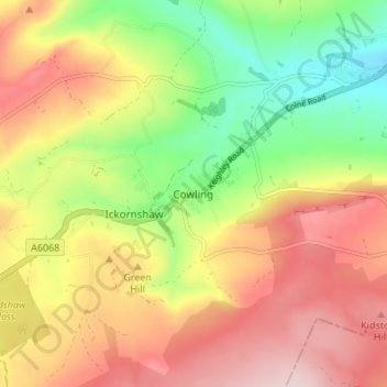
Name: Cowling topographic map, elevation, terrain.
Average elevation: 257 m
Minimum elevation: 118 m
Maximum elevation: 389 m
North Yorkshire trails, hiking, mountain biking, running and outdoor activities
Make a donation
Gear up for your next adventure:
As an Amazon Associate, this site earns from qualifying purchases at no extra cost to you.
Other topographic maps
Click on a map to view its topography, its elevation and its terrain.
Grimwith Reservoir
United Kingdom > England > North Yorkshire > Craven District
Average elevation: 320 m
River Aire
United Kingdom > England > North Yorkshire > Craven District > Malham > Hanlith
Average elevation: 237 m
Bastow Wood
United Kingdom > England > North Yorkshire > Craven District > Conistone
Average elevation: 244 m
Make a donation
Gear up for your next adventure:
As an Amazon Associate, this site earns from qualifying purchases at no extra cost to you.