
Town of Forestport topographic map
Interactive map
Click on the map to display elevation.
About this map
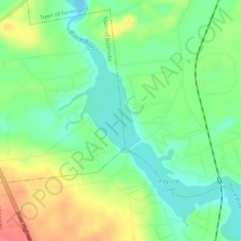
Name: Town of Forestport topographic map, elevation, terrain.
Location: Town of Forestport, Oneida County, New York, United States (43.41424 -75.20314 43.41485 -75.20161)
Average elevation: 366 m
Minimum elevation: 340 m
Maximum elevation: 405 m
Other topographic maps
Click on a map to view its topography, its elevation and its terrain.
City of Rome
United States > New York > Oneida County
The critical east/west American trade route through the frontier was improved by construction of the Erie Canal. On July 4, 1817, construction on the canal began in Rome. The Erie Canal reaches a summit in Rome, attaining an elevation of 420 feet. The first phase was completed in 1825, connecting the Hudson…
Average elevation: 190 m
Village of Clayville
United States > New York > Oneida County > Town of Paris
Average elevation: 361 m
City of Utica
United States > New York > Oneida County
The city's Mohawk name, Unundadages ("around the hill") refers to a bend in the Mohawk River that flows around the city's elevated position as seen from the Deerfield Hills in the north. The Erie Canal and Mohawk River pass through northern Utica; northwest of downtown is the Utica Marsh, a group of cattail…
Average elevation: 183 m
City of Rome
United States > New York > Oneida County
The critical east/west American trade route through the frontier was improved by construction of the Erie Canal. On July 4, 1817, construction on the canal began in Rome. The Erie Canal reaches a summit in Rome, attaining an elevation of 420 feet. The first phase was completed in 1825, connecting the Hudson…
Average elevation: 190 m
City of Utica
United States > New York > Oneida County
The city's Mohawk name, Unundadages ("around the hill") refers to a bend in the Mohawk River that flows around the city's elevated position as seen from the Deerfield Hills in the north. The Erie Canal and Mohawk River pass through northern Utica; northwest of downtown is the Utica Marsh, a group of cattail…
Average elevation: 183 m
Village of Oriskany Falls
United States > New York > Oneida County > Village of Oriskany Falls
Average elevation: 332 m
Village of Holland Patent
United States > New York > Oneida County > Town of Trenton
Average elevation: 205 m
City of Utica
United States > New York > Oneida County
The city's Mohawk name, Unundadages ("around the hill") refers to a bend in the Mohawk River that flows around the city's elevated position as seen from the Deerfield Hills in the north. The Erie Canal and Mohawk River pass through northern Utica; northwest of downtown is the Utica Marsh, a group of cattail…
Average elevation: 183 m