
Babati topographic map
Interactive map
Click on the map to display elevation.
About this map
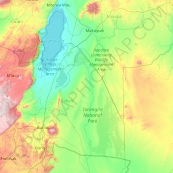
Name: Babati topographic map, elevation, terrain.
Location: Babati, Manyara, Northern Zone, Tanzania (-4.47050 35.27599 -3.39265 36.45169)
Average elevation: 1,321 m
Minimum elevation: 951 m
Maximum elevation: 2,408 m
Other topographic maps
Click on a map to view its topography, its elevation and its terrain.
Nyumba ya Mungu
Tanzania > Manyara > Nyumba ya Mungu
Nyumba ya Mungu, Simanjiro, Manyara, Northern Zone, Tanzania
Average elevation: 689 m