

Make a donation
Gear up for your next adventure:
As an Amazon Associate, this site earns from qualifying purchases at no extra cost to you.
Utica topographic map
Click on the map to display elevation.
Make a donation
Gear up for your next adventure:
As an Amazon Associate, this site earns from qualifying purchases at no extra cost to you.
Utica
The city's Mohawk name, Unundadages ("around the hill") refers to a bend in the Mohawk River that flows around the city's elevated position as seen from the Deerfield Hills in the north. The Erie Canal and Mohawk River pass through northern Utica; northwest of downtown is the Utica Marsh, a group of cattail wetlands between the Erie Canal and Mohawk River (partially in the town of Marcy) with a variety of animals, plants and birds. During the 1850s, plank roads were built through the marshland surrounding the city. Utica's suburbs have more hills and cliffs than the city. Located where the Mohawk Valley forms a wide floodplain, the city has a generally sloping, flat topography.
Make a donation
Gear up for your next adventure:
As an Amazon Associate, this site earns from qualifying purchases at no extra cost to you.
About this map
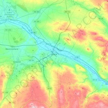
Name: Utica topographic map, elevation, terrain.
Average elevation: 268 m
Minimum elevation: 116 m
Maximum elevation: 585 m
Make a donation
Gear up for your next adventure:
As an Amazon Associate, this site earns from qualifying purchases at no extra cost to you.