
نوشاخ topographic map
Interactive map
Click on the map to display elevation.
About this map
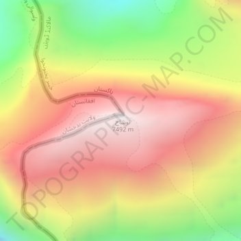
Name: نوشاخ topographic map, elevation, terrain.
Location: نوشاخ, Chitrāl District, خیبر پختونخوا, Pakistan (36.43494 71.83841 36.43504 71.83851)
Average elevation: 6,856 m
Minimum elevation: 6,018 m
Maximum elevation: 7,465 m
Other topographic maps
Click on a map to view its topography, its elevation and its terrain.
Tirich Mir
Tirich Mir, Chitrāl District, خیبر پختونخوا, Pakistan
Average elevation: 6,886 m
Istor-o-Nal
Istor-o-Nal, Chitrāl District, خیبر پختونخوا, Pakistan
Average elevation: 6,853 m