
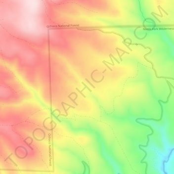
Hail Creek topographic map
Interactive map
Click on the map to display elevation.
About this map
Name: Hail Creek topographic map, elevation, terrain.
Location: Hail Creek, Crook County, Oregon, United States of America (44.22241 -120.17710 44.24846 -120.12697)
Average elevation: 1,412 m
Minimum elevation: 1,215 m
Maximum elevation: 1,555 m
Other topographic maps
Click on a map to view its topography, its elevation and its terrain.
Boring
United States of America > Oregon > Boring
Boring, Clackamas County, Oregon, 97009, United States of America
Average elevation: 183 m
Rhododendron
United States of America > Oregon > Rhododendron
Rhododendron, The Villages at Mount Hood, Clackamas County, Oregon, 97049, United States of America
Average elevation: 735 m
Iron Knob
United States of America > Oregon
Iron Knob, Jackson County, Oregon, United States of America
Average elevation: 861 m
Morton Island
United States of America > Oregon
Morton Island, Malheur County, Oregon, United States of America
Average elevation: 661 m
Wemme
United States of America > Oregon > Wemme
Wemme, The Villages at Mount Hood, Clackamas County, Oregon, 97067, United States of America
Average elevation: 494 m
Barlow
United States of America > Oregon > Barlow
Barlow, Clackamas County, Oregon, United States of America
Average elevation: 31 m
Lake County
United States of America > Oregon
Lake County, Oregon, United States of America
Average elevation: 1,540 m
McKenzie River
United States of America > Oregon
McKenzie River, Lane County, Oregon, 97413, United States of America
Average elevation: 431 m
Hillsboro
United States of America > Oregon > Hillsboro
Hillsboro, Washington County, Oregon, United States of America
Average elevation: 53 m