
Kowie River topographic map
Interactive map
Click on the map to display elevation.
About this map
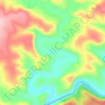
Name: Kowie River topographic map, elevation, terrain.
Average elevation: 240 m
Minimum elevation: 144 m
Maximum elevation: 351 m
Other topographic maps
Click on a map to view its topography, its elevation and its terrain.
Thomas Baines Nature Reserve
RSA > Eastern Cape > Makana Local Municipality
Thomas Baines Nature Reserve, R343, Makana Ward 13, Makana Local Municipality, Sarah Baartman District Municipality, Eastern Cape, RSA
Average elevation: 373 m
Shamwari Private Game Reserve
RSA > Eastern Cape > Makana Local Municipality
Shamwari Private Game Reserve, Makana Ward 14, Makana Local Municipality, Sarah Baartman District Municipality, Eastern Cape, RSA
Average elevation: 356 m
Coleridge Game Reserve
RSA > Eastern Cape > Makana Local Municipality
Coleridge Game Reserve, R67, Makana Ward 13, Makana Local Municipality, Sarah Baartman District Municipality, Eastern Cape, 6139, RSA
Average elevation: 392 m
Makana Ward 6
RSA > Eastern Cape > Makana Local Municipality
Makana Ward 6, Makana Local Municipality, Sarah Baartman District Municipality, Eastern Cape, RSA
Average elevation: 637 m