
Thank you for supporting this site ❤️
Make a donation
Make a donation
Gear up for your next adventure:
As an Amazon Associate, this site earns from qualifying purchases at no extra cost to you.
Panipat topographic map
Click on the map to display elevation.
Thank you for supporting this site ❤️
Make a donation
Make a donation
Gear up for your next adventure:
As an Amazon Associate, this site earns from qualifying purchases at no extra cost to you.
Panipat
Panipat is located at 29°23′15″N 76°58′12″E / 29.3875°N 76.9700°E / 29.3875; 76.9700. It has an average elevation of 219 metres (718 feet).
Thank you for supporting this site ❤️
Make a donation
Make a donation
Gear up for your next adventure:
As an Amazon Associate, this site earns from qualifying purchases at no extra cost to you.
About this map
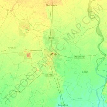
Name: Panipat topographic map, elevation, terrain.
Location: Panipat, Haryana, 132100, India (29.23128 76.81717 29.55128 77.13717)
Average elevation: 235 m
Minimum elevation: 223 m
Maximum elevation: 250 m
Thank you for supporting this site ❤️
Make a donation
Make a donation
Gear up for your next adventure:
As an Amazon Associate, this site earns from qualifying purchases at no extra cost to you.