
Castlemaine topographic map
Click on the map to display elevation.
Castlemaine
The Castlemaine goldfields' legendary prosperity raised expectations of Castlemaine becoming Victoria's second city. That is reflected in imposing buildings erected in the town's first few years. Though the rich alluvial diggings were largely exhausted within 15–20 years causing the town's population to shrink after the 1870s, a rich legacy remains in the form of its buildings and intact nineteenth century streetscapes comprising public buildings as well as simple miners' cottages. The historic area tells the history of Castlemaine in relics of significance, including the former steam flourmill (now 'The Mill'), the Church of England, and the Congregational Church, and despite the town's topographical limitation to the valley of the two creeks, broad streets and grand buildings convey an atmosphere of spaciousness.
About this map
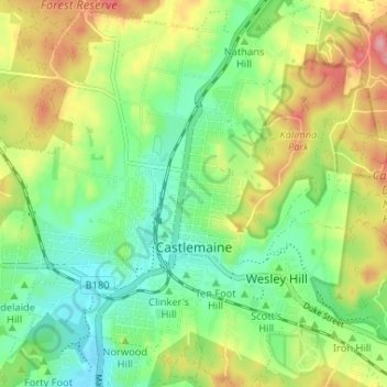
Name: Castlemaine topographic map, elevation, terrain.
Average elevation: 319 m
Minimum elevation: 267 m
Maximum elevation: 401 m
Other topographic maps
Click on a map to view its topography, its elevation and its terrain.
Ballarat
Ballarat has a moderate oceanic climate (Köppen climate classification Cfb) with four distinct seasons. Its elevation, ranging between 400 and 630 metres (1,310 and 2,070 feet) above sea level, causes its mean monthly temperatures to tend to be on average 3 to 5 °C (5 to 9 °F) below those of Melbourne,…
Average elevation: 470 m
Melbourne
Melbourne is also prone to isolated convective showers forming when a cold pool crosses the state, especially if there is considerable daytime heating. These showers are often heavy and can include hail, squalls, and significant drops in temperature, but they often pass through very quickly with a rapid…
Average elevation: 49 m
Castlemaine
The Castlemaine goldfields' legendary prosperity raised expectations of Castlemaine becoming Victoria's second city. That is reflected in imposing buildings erected in the town's first few years. Though the rich alluvial diggings were largely exhausted within 15-20 years causing the town's population to shrink…
Average elevation: 331 m
Mount Dandenong
Australia > Victoria > Melbourne
Mount Dandenong has a cool oceanic climate (Cfb), with cool to mild summers and cold, damp winters. Daytime temperatures are usually 4−6 °C cooler than downtown Melbourne due to its elevation and distance from the urban heat island effect of Melbourne. It is significantly cloudier than Melbourne,…
Average elevation: 395 m
Mount Bogong
The Big River separates the massif of the mountain from the Bogong High Plains to the south. From the nearby town of Mount Beauty to its summit, Mount Bogong rises more than 1,600 metres (5,200 ft), thus making it one of the highest peaks in Australia not only in terms of its elevation above sea level, but…
Average elevation: 1,719 m
Buffalo Plateau
The summit of the highest peak of the plateau, known as The Horn, has an elevation of 1,723 metres (5,653 ft) AHD.
Average elevation: 1,502 m